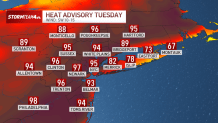
A surge of summer air has prompted a Heat Advisory to be issued for portions of the tri-state area on Tuesday and Wednesday.

Temperatures will peak in the mid-90s away from the coast, with heat index readings between 95 and 99 degrees during the hottest part of the day.
If you’re planning to be outside in the heat for long periods of time, keep your activity level low and drink plenty of water. Tuesday and Wednesday will be the hottest days of the year so far, and this early in the season, extreme heat can be a shock to our bodies.
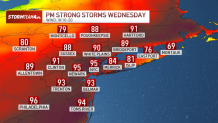
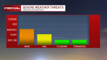
Along with the heat, we’ll be dealing with storms. Isolated storms are possible Tuesday afternoon, but they’ll be more likely on Wednesday, ahead of a cold front that will deliver our heat relief.

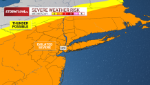
A few storms could produce damaging wind gusts or large hail, so make sure you stay one step ahead of the weather and download the NBC New York app to your phone. Turn weather alerts on, and you’ll receive a notification when severe weather moves into your neighborhood.
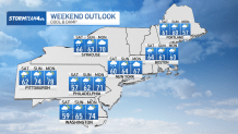
Storms will clear the area on Wednesday night, with much cooler air poised to envelop the region into the Memorial Day Weekend. Highs will hold mainly in the 60s with rain likely as we head into Saturday. It could linger into Sunday and possibly even Monday, we dry out completely and begin to warm up again after Memorial Day.